High above the ocean, a small satellite captures unusual activity in open water. Hundreds of miles below, a Coast Guard cutter quietly dispatches an unmanned aircraft to gather additional visual and thermal imagery. Meanwhile, operators at a command center back on shore view the feed from both platforms in real time. The info is clear, persistent, and actionable.
This isn’t a scene from the future. It’s happening now—and it's only going to get better.
As part of the Force Design 2028 initiative, the Coast Guard will accelerate the adoption of the latest technologies to enhance data sharing, situational awareness, and operational effectiveness across the marine domain. But to be effective, these new tools must be integrated into a more connected system—one that’s able to ensure the right information gets in front of decisionmakers when they need it.
That’s where Project Minerva comes in. Minerva, named after the Roman goddess of strategy and wisdom, is a multi-year effort that is transforming how the Service achieves maritime domain awareness. By integrating emerging technology across air, sea, land, and space, Minerva is helping us transition from legacy “patrol and interdict” tactics toward a faster, more effective model: “target and interdict.”
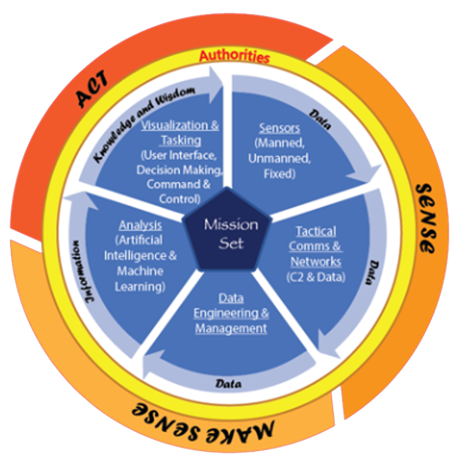
At the heart of this transformation is a clear framework for handling data gathered in the field: Sense, Make Sense, and Act. This article—the first in a three-part series—focuses on how Project Minerva is increasing the Coast Guard’s ability to “sense” what’s happening in the maritime domain using next-generation platforms, sensors, and communications networks.
Expanding Our Senses
Traditionally, Coast Guard operations have relied heavily on the eyes and ears of our people—lookouts scanning the horizon, crews watching radar, and operators passing along what they see. But today’s technology is expanding what we can detect, where, and how fast.
From manned cutters and aircraft to unmanned systems and remote installations, the Coast Guard is witnessing a rapid increase in our ability to gather raw data across vast swaths of ocean. We're using more sensors in more places than ever before—on the water, in the air, ashore, and even in orbit.
But collecting data is just the start. We need to make that data accessible across the fleet, from command centers to boarding teams. That means connecting sensors and platforms into a coordinated, mission-ready operational data system—a task that Project Minerva was built to lead.
Smarter Sensors, Smaller Packages
Sensors are evolving fast—and they’re becoming smaller, lighter, and more powerful. While the Coast Guard has long used radar and Electro-Optical/Infra-Red (EO/IR), new sensing technologies like hyperspectral imaging are unlocking the ability to identify vessels and materials by their unique spectral signatures – even through haze, darkness, or cloud cover.
Miniaturization is a game changer. Today’s advanced sensors can be deployed not only on major cutters or aircraft, but also on small drones, remote land sites, and even satellites. This enables persistent, flexible coverage of key maritime regions without adding strain to human operators.
Connected Everywhere
Of course, sensing only matters if we can move the data. That’s why communication and networking advances are just as critical.
Minerva is working with partners across the Coast Guard to integrate modern digital radios, mesh networks, and commercial satellite communications. These systems are scalable and power-efficient, meaning they can extend reliable connectivity to distant units – including small boats, unmanned systems, and teams operating far offshore.
Some of these networks can be powered by solar or battery power for weeks or months. Others can form private Coast Guard-specific wireless networks, stitching together platforms into a seamless mesh capable of sharing real-time data across the fleet.
The technology exists. The challenge is integrating it the right way. Project Minerva isn’t developing technology and it’s not working in isolation. It’s working to ensure integration across the system, ensuring that platforms, sensors, and networks are matched for mission effectiveness and designed to scale.
By working across CG offices—like CG-7, CG-2 AI, and C5ISC—Minerva is coordinating investments, pilots, and deployments that feed into one connected operational picture. Here are a few examples:
- Saildrone USVs: In partnership with CG-7, Minerva is helping evaluate and deploy unmanned surface vessels capable of long-endurance surveillance. These vessels are contractor-operated, equipped with EO/IR cameras and radar, and can operate autonomously for months, sending real-time data to command centers via satellite.
- WAMOR (Wide Area Maritime Object Recognition): Minerva is working with the Department of Homeland Security’s Science & Technology (DHS S&T) and CG-2’s AI team to test commercial hyperspectral sensors that use non-visible bands to detect and classify objects – even in poor visibility. These technologies could greatly enhance the detection capabilities of Maritime Patrol Aircraft and UAS.
- Proliferated Low-Earth Orbit (pLEO) Satellite Communications: The rapid proliferation of satellites into Low Earth Orbit has drastically expanded the sensing and communications architecture for both government and the private sector. C5ISC is rolling out commercial satellite comms to drastically increase bandwidth on major cutters. This opens the door for real-time sensor sharing between cutters, aircraft, and shore-based units—an operational breakthrough already taking shape.
Looking Ahead
Project Minerva is laying the foundation for a fully connected Coast Guard—where sensing is continuous, persistent, and shared across the force. But sensing is only step one.
In the next article, we’ll explore how Minerva is helping the Coast Guard “make sense” of the data we collect—turning raw inputs into real-time intelligence for decision-makers and operators alike.
To learn more, visit the Project Minerva SharePoint site or reach out to the team at ProjectMinerva@uscg.mil.
-USCG-